
Map of greenways and cycle routes
50024.60 km of cycle paths across 913 greenways
Discover the map of greenways, cycle routes and bike paths in France.
Find tourist accommodations nearby to plan your stay, your trip or your cycling holiday.
Flax Cycle Route Greenway (from Fécamp to Dieppe)
The Flow Vélo
Greenway of the Two Saars (Sarrebourg - Abreschviller) - Moselle
Green Way The coastline (Narbonne - Gruissan - St Pierre la Mer)
V80 Canal du Midi Greenway: Toulouse - Sète
Avenue Verte London - Paris
Southern Burgundy Green Route Châlon-Givry-Cluny
Greenway: Via Velay (Le Puy - Costaros - Landos)
V40: The Véloscénie Paris - Mont St Michel
The Vélofrancette: Mayenne - Laval Green Route (V43)
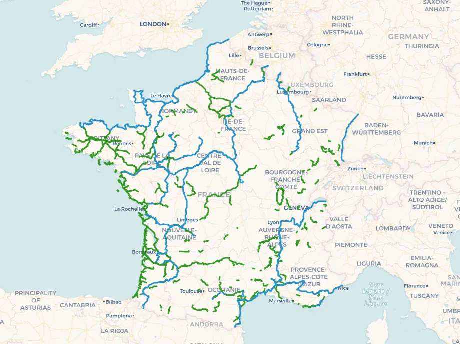
The map of greenways in France is an essential tool for anyone who wants to explore the country by bike. These purpose-built routes allow cyclists to travel safely and peacefully, far from motorised traffic. A cycling holiday in France delivers a one-of-a-kind experience, combining heritage discovery, stunning landscapes and pure downtime.
Cycling along the bike paths and cycle routes of France
The cycle paths spread across France are varied and suited to every level. Whether you're a beginner or a seasoned long-distance rider, there's a safe cycling itinerary for your trip. Riding along cycle paths lets you immerse yourself in nature, discover picturesque villages and enjoy the great outdoors.
Complete map of greenways, cycle paths and safe cycling routes in France
Planning a cycling itinerary along the greenways and cycle paths of France is an exciting experience. Depending on your taste and ability, you can choose shorter or longer cycling loops, with stages designed for resting and exploring nearby. Cycling tourism in France is a great way to enjoy active and rewarding holidays.
How can I find greenways near me?
To find greenways near you, visit the specialised website Ma Voie Verte, which can use your location to run "greenways near me" searches.
You can also visit local tourism offices or their websites for information on the greenways and cycle paths in your area.
Map of tourist accommodations close to the greenways
Accueil Vélo, the label you can trust
The "Accueil Vélo" label guarantees quality services for cycling tourists in France. It is awarded to accommodations, restaurants, tourism offices and tourist sites that meet specific criteria: secure bike shelters, repair kits, route information and tailored advice. This label ensures cyclists a warm welcome and the right facilities throughout their journey.
Gite, campsite, hotel, bed & breakfast close to greenways and cycle paths
Thanks to the interactive map of greenways, plan your stay or your cycling tour in France and book your accommodation from a selection of gites, bed & breakfasts, campsites and hotels located close to the greenways.
Frequently asked questions about greenways
How can I find a map of greenways in France?
The map of greenways and cycle paths can be viewed online on the Ma Voie Verte website, which lists greenways, cycle routes and cycling itineraries in France along with nearby tourist accommodations.
Are the greenway maps updated regularly?
Yes, the map of greenways and cycle paths on Ma Voie Verte is regularly updated to reflect new infrastructure and route changes.
Are greenways safe for children?
Yes, greenways are designed to be safe and accessible to everyone, including children. They are generally separated from motorised traffic.
Can I see on a map which accommodations are available along the greenways and cycle paths?
Yes, many accommodations (campsites, gites, hotels, bed & breakfasts, unusual stays) are available along the greenways and cycle paths. They are all featured on the Ma Voie Verte map.
What's the difference between a greenway and a cycle path?
A greenway is a route reserved for non-motorised travel — walking, cycling, rollerblading — providing a safe and peaceful environment, often built on former railway lines or towpaths. A cycle path, on the other hand, is a lane specifically designed for cyclists, usually located alongside roads and separated by markings or a barrier, making urban cycling easier. Both types of infrastructure aim to promote soft mobility.
How do I plan a cycling itinerary or trip in France?
To plan a cycling itinerary, check the map of greenways, choose your stages based on your interests and ability, and be sure to check accommodation and dining options along the way.